
Our readers keep the lights on and the weekend projects moving. As an Amazon Associate, I earn from qualifying purchases.
The difference between a great day on the trail and an emergency survival situation often comes down to a single coordinate. A smartphone with a spotty signal won’t cut it when you’re deep in a canyon, under dense tree cover, or miles from the nearest cell tower. A dedicated backpacking GPS is the only gear that delivers reliable, all-day positioning and the peace of mind that comes with knowing exactly where you are and exactly how to get home.
I’m Rikta — the co-founder and writer behind FitlyFast. I’ve spent hundreds of hours analyzing satellite receiver specs, battery life claims, and real-world user feedback to cut through the marketing noise and identify which handheld navigation units actually deliver in the backcountry.
Whether you’re a weekend hiker, a multi-day backpacker, or a serious off-trail explorer, the right backpacking gps is a lifeline that fits in your palm and never needs a signal bar to tell you where you are.
How To Choose The Best Backpacking GPS
A good backpacking GPS is more than a digital compass. It’s your primary navigation tool when the trail disappears, the fog rolls in, or darkness falls. Choosing the right one means understanding which specs translate to real backcountry performance and which ones are just marketing noise.
Satellite Connectivity: Multi-GNSS and Multi-Band
The core job of a GPS is to lock onto satellites. A basic receiver uses only the US GPS network. A unit with multi-GNSS support pulls from GPS, GLONASS, Galileo, and BeiDou, which means it can lock onto more satellites faster, especially in a narrow canyon or under a heavy conifer canopy. Multi-band receivers go even further by using two frequencies from each satellite, canceling out signal errors caused by the ionosphere. This is the spec that delivers sub-10-foot accuracy in the worst conditions.
Battery Life and Power Strategy
For a multi-day backpacking trip, every ounce of battery weight matters. Units that run on two standard AA batteries let you carry spares and swap instantly, effectively giving you unlimited runtime as long as you have fresh cells. Internal rechargeable batteries are convenient for day hikes and require a power bank or solar panel for longer trips. Pay close attention to the battery life numbers: the best units offer over 100 hours in standard mode or an expedition mode that stretches power to weeks by only pinging satellites periodically.
Display, Maps, and Durability
A sunlight-readable screen is non-negotiable. A dim LCD that washes out at noon is useless. Physical buttons are far more reliable than a touchscreen when your hands are wet, cold, or gloved. Preloaded TopoActive maps save you the hassle of downloading and transferring map data at home. For durability, look for an IPX7 water-resistance rating, which means the unit can survive immersion in one meter of water for 30 minutes. A rugged drop-rated casing matters too — a GPS is no good if it shatters on a rocky trail.
Quick Comparison
On smaller screens, swipe sideways to see the full table.
| Model | Category | Best For | Key Spec | Amazon |
|---|---|---|---|---|
| Garmin GPSMAP 65s | Premium Handheld | Accurate navigation in extreme terrain | Multi-band GNSS + 3-axis compass | Amazon |
| Garmin GPSMAP 64sx | Premium Handheld | Off-trail hiking with preloaded topo maps | Quad helix antenna + 16hr battery | Amazon |
| Garmin GPSMAP 86sci | Marine/InReach Combo | Water-based exploration with SOS | Floating design + Iridium two-way | Amazon |
| Garmin GPS 73 | Mid-Range Marine | Basic navigation on sailboats | 18hr battery + SailAssist features | Amazon |
| Garmin eTrex SE | Value Handheld | Ultra-long battery for thru-hikes | 168hr standard / 1800hr expedition | Amazon |
| Spot X | Satellite Messenger | Two-way emergency messaging off-grid | Globalstar satellite + SOS button | Amazon |
| Bushnell BackTrack Mini | Compact Route Finder | Simple point-to-point backtracking | 35hr battery + Bluetooth sync | Amazon |
| NiesahYan Handheld GPS | Budget Navigator | Entry-level GPS with preloaded USA maps | 36hr battery + 32GB memory | Amazon |
In‑Depth Reviews
1. Garmin GPSMAP 65s

The Garmin GPSMAP 65s is the benchmark for serious backcountry navigation. Its multi-band GNSS receiver pulls from GPS, GLONASS, Galileo, and QZSS on two frequencies, delivering position accuracy around six feet even in steep terrain, urban canyons, or under dense tree cover — places where standard GPS receivers drift by 30 feet or more. The large 2.6-inch sunlight-readable color display is crisp in direct sun, and the physical button layout lets you operate it confidently with gloves on or in a rainstorm.
Battery life is strong for a premium unit. In GPS mode with battery saver engaged, you can expect around 27 hours from a pair of AA NiMH cells. Switch to multi-GNSS with multi-band and that drops to 17 hours, but you get the best possible accuracy. The built-in 3-axis compass and barometric altimeter (ABC sensors) provide bearing and elevation data even when you’re standing still, which is critical for route confirmation. It comes preloaded with TopoActive maps and public land boundaries for the U.S., so you’re ready to explore right out of the box.
The learning curve is real — Garmin’s interface hasn’t changed much in a decade, and setting up custom maps via BaseCamp on a Mac can be frustrating. Once configured, though, the 65s is a rock-solid, IPX7-rated tool that won’t let you down. It also pairs with the Garmin Explore app for smart notifications and trip planning. For hikers, backpackers, and off-trail explorers who demand the best position lock, the GPSMAP 65s is the gold standard.
Why it’s great
- Multi-band GNSS gives sub-10-foot accuracy in challenging conditions
- Sunlight-readable 2.6″ color display with dedicated buttons
- Reliable 27-hour battery on AA NiMH in GPS mode
- Preloaded TopoActive maps and public land boundaries
Good to know
- Garmin BaseCamp software can be clunky, especially on Mac
- Default topo maps lack detail in some areas; custom maps require work
- AA batteries not included
2. Garmin GPSMAP 86sci

The GPSMAP 86sci is a specialized tool designed for the water, but its capabilities are broad enough to serve any backpacker who ventures near lakes, rivers, or coastlines. It’s built to float, so dropping it overboard isn’t a disaster, and its 3-inch sunlight-visible display is the largest in this roundup. The preloaded BlueChart G3 coastal charts combine Garmin and Navionics data, making it a top choice for paddle trips and coastal exploration where topo maps aren’t enough.
The real differentiator here is the integrated inReach satellite communication. Via the 100% global Iridium satellite network, you can send two-way text messages and trigger an interactive SOS to a 24/7 search and rescue center. Battery life is solid at over 24 hours of continuous GPS use, and the device can stream boat data from compatible chartplotters. The rubberized grip and button operation are easy to use with wet hands, and the unit includes a powered mount for a boat or kayak.
This capability comes with a catch: the inReach features require an active satellite subscription, which adds ongoing cost. The screen, despite being 3 inches, can feel small for detailed chart work, and the interface requires some scrolling to access main functions. For the backpacker who also paddles or wants the security of satellite SOS without carrying a separate messenger, the 86sci is an elegant all-in-one.
Why it’s great
- Floating design with a 3″ sunlight-visible display
- Integrated Iridium inReach for global two-way messaging and SOS
- Preloaded BlueChart G3 coastal charts for water navigation
- More than 24 hours of battery life in GPS mode
Good to know
- Satellite subscription required for messaging and SOS features
- Screen is small for detailed chart work
- Interface navigation can feel clunky
3. Garmin GPSMAP 64sx

The Garmin GPSMAP 64sx is a workhorse that prioritizes reliability and signal strength over the latest multi-band tech. Its quad helix antenna provides excellent reception in marginal conditions, and with multi-GNSS support covering GPS, GLONASS, and Galileo, it locks quickly and holds a signal in steep terrain and heavy woods. The 2.6-inch sunlight-readable color display is the same size as the 65s, and the button-only interface works flawlessly in rain, snow, or with gloves.
It comes preloaded with TopoActive maps for the U.S. and Australia, featuring routable roads and trails. The 3-axis compass and barometric altimeter give you bearing and elevation data on demand, and wireless connectivity via Bluetooth and ANT+ allows pairing with heart rate monitors, temperature sensors, and the Garmin Explore app. Battery life is rated at 16 hours in GPS mode using two AA batteries, and you can extend that with lithium cells. The microSD slot lets you add more detailed maps when needed.
The internal memory is limited, and the unit doesn’t come with a memory card or adapter, so you’ll need to buy one to load custom maps. The manual isn’t pre-installed on the device, and the BaseCamp software is essential but clunky. For hikers and off-trail explorers who want a proven, rugged GPS with strong reception and wireless features, the 64sx is a dependable choice that won’t break the bank like the 65s.
Why it’s great
- Quad helix antenna provides excellent signal lock in tough conditions
- Preloaded TopoActive maps and ABC sensors included
- Wireless connectivity via Bluetooth and ANT+
- Button operation works perfectly in wet or cold conditions
Good to know
- Limited internal memory; microSD card and adapter not included
- Manual not pre-installed on the device
- Battery life is 16 hours — bring spares for multi-day trips
4. Garmin eTrex SE

The Garmin eTrex SE is the battery-life champion of the group. It runs for up to 168 hours in standard GPS mode and an astonishing 1,800 hours in expedition mode using two field-replaceable AA batteries. That kind of endurance makes it the obvious choice for thru-hikes, multi-week expeditions, or any trip where recharging isn’t an option. The 2.2-inch high-resolution display isn’t the largest, but it’s perfectly readable in bright sunlight, and the monochrome screen contributes to the incredible power efficiency.
It supports multi-GNSS (GPS, GLONASS, Galileo, BeiDou, QZSS) for faster locks and better accuracy than a GPS-only unit. The digital compass gives an accurate heading even when you’re standing still, and the IPX7 water-resistance means it can survive a rainstorm or a dunk in a stream. Pair it with the Garmin Explore app on your smartphone to get wireless software updates, trip planning, Active Weather, smart notifications, and Geocaching Live data. The Bluetooth connection also lets you upload tracks to your phone for sharing.
The interface is basic and the menu navigation can be clunky — some users report a learning curve to find all the features. The screen is monochrome, so you won’t get colorful topo maps, but the crisp text and icons are easy to read at a glance. The USB-C port is under the battery cover, which is a minor annoyance. For backpackers who prioritize battery life above all else and don’t need a color map display, the eTrex SE is an unbeatable tool.
Why it’s great
- Exceptional 168-hour battery life in standard mode
- Expedition mode stretches to 1,800 hours (75 days)
- Multi-GNSS support for fast, accurate satellite locks
- Pairs with Garmin Explore app for trip planning and weather
Good to know
- Monochrome display — no color topo maps
- Menu navigation is clunky and takes practice
- USB-C port is under the battery cover
5. Spot X

The Spot X is primarily a satellite messenger that also tracks your position, making it a specialist tool for anyone who needs to stay in contact with the outside world when cell service vanishes. It uses the Globalstar satellite network to send and receive text messages, and the built-in SOS button connects you to a 24/7 search and rescue center. It also has its own dedicated US mobile number, so friends and family can text you directly. The battery lasts up to 240 hours in tracking mode, which is a solid week of continuous use.
It’s a rugged device with a plastic enclosure and a built-in carabiner for easy attachment to a pack strap. The full QWERTY keyboard lets you type custom messages, and Bluetooth sync lets you pair it with your smartphone for easier messaging via the Spot app. You can also use it as a standalone communicator without a phone. The included kickstand is handy for keeping it upright on a camp table while you wait for a message.
The subscription cost is a recurring expense, and the Globalstar network has some limitations — 5G interference can block incoming messages in urban fringe areas, and the device needs a clear view of the sky. The keypad keys are small and the interface is slow. Some users report the device turning off or pausing tracking without warning. For deep backcountry trips where two-way emergency communication is a priority, the Spot X is a reliable choice, but it’s not a full GPS navigator for route planning.
Why it’s great
- Two-way satellite messaging and SOS via Globalstar
- 240-hour battery life in tracking mode
- Dedicated US phone number for family to text you
- Rugged build with built-in carabiner and kickstand
Good to know
- Requires a paid satellite subscription
- 5G interference can block incoming messages
- Small keypad and slow interface; tracking can pause unexpectedly
6. Garmin GPS 73
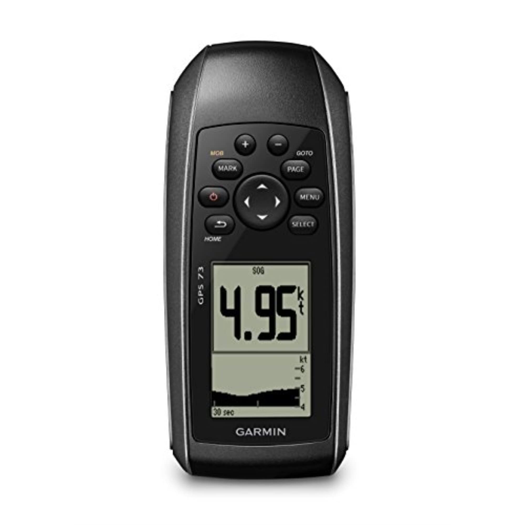
The Garmin GPS 73 is a no-frills, marine-focused GPS that strips away unnecessary complexity and focuses on core navigation data. It’s designed primarily for boaters and sailors, but its ability to display GPS coordinates, speed, and course over ground makes it a functional backup for any backpacker who navigates with paper charts. The 2.6-inch display is monochrome and sunlight-readable, offering a crisp 128 x 160 pixel resolution that’s easier on the eyes than a touchscreen in bright conditions.
Its key feature is SailAssist, which includes a virtual starting line, countdown timers, speed history, and tack assist for sailors. For the backpacker, the marine alarm system (off course, anchor drag) and route planning are useful on any water-based trip. The device stores up to 1,000 waypoints and 100 tracks. Battery life is 18+ hours from two AA batteries, which is decent for a basic unit but falls short of the eTrex SE’s marathon performance. The interface is simple and intuitive with dedicated backlit buttons.
The GPS 73 lacks any wireless connectivity — no Bluetooth, no ANT+, no app pairing. You can’t sync tracks to your phone or receive smart notifications. The position update rate is adjustable from one second, but some users report slow response when walking quickly during fieldwork. This is a tool for pure position accountability, not for detailed map navigation. For boaters and budget-conscious hikers who just need a reliable coordinate logger, the GPS 73 gets the job done.
Why it’s great
- Simple, intuitive interface with dedicated buttons
- Sunlight-readable monochrome display
- SailAssist features for water navigation
- 18-hour battery from standard AA batteries
Good to know
- No Bluetooth, ANT+, or wireless connectivity
- Slow position update when walking
- Basic feature set — no color maps or detailed terrain views
7. Bushnell BackTrack Mini

The Bushnell BackTrack Mini is a compact, lightweight GPS designed for one main job: getting you back to where you started. It captures your starting position as a waypoint and guides you back to your trailhead or base camp using directional arrows and distance-to-go data. It’s not a full map navigator — there are no topo maps or detailed terrain views — but for quick day hikes, hunts, or fishing trips where you just need a reliable backtracking tool, it’s hard to beat the simplicity.
Battery life is rated up to 35 hours from the internal rechargeable battery, which is competitive for the size. The LCD display is easy to read in daylight, and the large, glove-friendly buttons make operation easy in any weather. It also provides elevation gain and loss, barometric pressure, sunrise/sunset, and moonrise/moonset times. Bluetooth connectivity lets you sync trips and waypoints to the Bushnell Connect app on your smartphone for sharing or later review. The micro-USB charging is a bit dated, but the device is rugged and waterproof.
The biggest downside is that it’s not a full GPS navigator — you can’t plan a multi-point route or see a map. The app can be unreliable, with some users reporting that data won’t download from the device after use. The distance tracking can overestimate by up to 60%, and elevation readings can be off by over 200 feet in some cases. For the price, the functionality is basic. The BackTrack Mini is best viewed as a safety net for short trips, not a primary navigation tool for serious backpacking.
Why it’s great
- Ultra-simple interface for quick backtracking
- 35-hour battery from internal rechargeable battery
- Large, glove-friendly buttons for easy use in any weather
- Compact and lightweight for day hikes
Good to know
- No topo maps or route planning features
- App reliability issues; data can fail to sync
- Distance overestimation and inaccurate elevation readings reported
8. NiesahYan Handheld GPS

The NiesahYan Handheld GPS is a budget-friendly entry point into dedicated GPS navigation. It offers a solid feature set for its price tier, including a 3.2-inch sunlight-readable LCD screen with physical buttons, preloaded USA topo maps, and multi-GNSS support (GPS, Galileo, BeiDou, QZSS) for location precision within about six feet. The 32 GB of internal memory provides ample space for additional map downloads, and the 36-hour battery life on a full charge is competitive for a unit in this class.
The device includes a 3-axis compass and barometric altimeter, both of which provide handy orientation and elevation data. The IP66 water-resistance rating means it can handle rain and splashes, though it’s not fully submersible like IPX7-rated units. The USB-C charging is a modern convenience, saving you from carrying a separate cable. The anti-slip design and button layout are practical, and the “save my spot” feature is simple and effective for marking a waypoint or your starting point.
The build quality and reliability are inconsistent. Multiple reviews report devices failing to boot after the first field test, entering an infinite reboot loop that is unrecoverable. Navigation through the menus can be confusing, and the manual is sparse and unhelpful. UTM coordinate accuracy has been questioned, with some users reporting incorrect bearings and poor waypoint plotting. This unit offers great specs on paper, but the execution quality control is a gamble. For the budget-conscious hiker willing to accept that risk, it could be a functional tool.
Why it’s great
- Large 3.2″ sunlight-readable screen with physical buttons
- 36-hour battery life with USB-C charging
- 32 GB internal memory for map storage
- Multi-GNSS support with preloaded USA topo maps
Good to know
- Reliability concerns — some units fail to boot after initial use
- Manual is sparse and confusing
- UTM coordinate accuracy and waypoint plotting can be inaccurate
FAQ
Do I need a subscription for a Backpacking GPS?
Can I use a Backpacking GPS to navigate without a map?
How accurate is a multi-band GPS under tree cover?
Final Thoughts: The Verdict
For most users, the backpacking gps winner is the Garmin GPSMAP 65s because it combines the best multi-band accuracy with preloaded topo maps, a 27-hour battery life on AA cells, and a button interface that works in any weather. If you want the ultimate battery endurance for a multi-week thru-hike, grab the Garmin eTrex SE. And for water-based trips where an SOS button and two-way satellite messaging are non-negotiable, nothing beats the Garmin GPSMAP 86sci.